Categories
birds environment evolution public participation in science

Birdy links

The fall semester has started this week, and the last few weeks leading up to it have been a whirlwind of getting set up for teaching, putting in conference proposals, and continuing to chip away on my visualization project. As a consequence of the latter, I am learning much more about birds than I thought I would. (Did you know that there is an Indonesian bird called the Satanic Nightjar? Now you do.)

All together, it has been a busy time. So, in an effort to at least keep posting occasionally on this blog, here are three recent bird-related links of interest:

  • First, a pretty cool story about a woman who built an outdoor run/play area for her cats, so that they would not kill songbirds, get hit by cars, mauled by dogs, or have to deal with other outdoor hazards. Cats- both feral and domestic- are actually quite a large threat to bird populations: the USFWS estimates that domestic outdoor cats kill upwards of 39 million birds a year! So this is a creative solution, and I have to say looks pretty fun for the cats.
  • Next, the Cornell Lab of Ornithology is building bird-recognition software that will ultimately be used to create a “smart” ID/advice system for people who need help IDing a bird. They’re asking for help from the public to help build the software by taking a “color challenge” that matches a color to a bird. The results will be used to help figure out how we see color when looking at birds. If you’ve maxed out your levels on Angry Birds, this might be a good substitute 🙂
  • Finally, a research blogging post on a study looking at the relationships between songbirds and parrots. The researchers studied retroposons (“jumping genes”) in several different types of birds, and confirmed another study a few years back that surprised people when it suggested that songbirds, parrots, and falcons were all closely related. The post gives you a good breakdown of the study and its importance.
Categories
environment information representation visuals

A century of overfishing, at a minimum

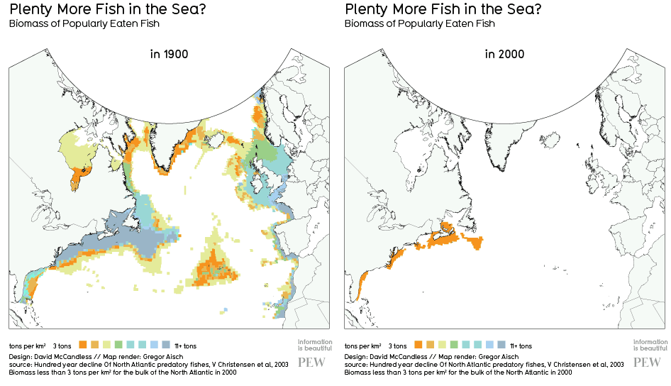
I ran across this animated GIF today, via Southern Fried Scientist, that vividly illustrates the effects of a century of overfishing on the biomass of fish in the North Atlantic. It’s a pretty stark visual depiction of changes that have happened to the oceans worldwide, in just the past century.

This image wascreated by Information is Beautiful‘s David McCandless from a PEW report on historic declines on several fish species. He posts about the image here, and includes a link to the cited report. In his post, McCandless points out that even by the 1900s, we had had a huge effect on the number of fish (and whales, and turtles, and seals, and sea cows, and so on…) in the sea. So one important thing to keep in mind for context is that the fish abundance from 1900 is not a “pre-human impact” point in time.

Categories
birds environment Florida

Duckling drama

This year, two sets of ducklings are being raised in our pond. Two years ago, another duck raised a brood of ducklings- I wonder if either of these females is from that brood?

The older brood is on the bank, and the younger brood is in the water. (Y. Fernandez)

These are wild ducks- possibly Mottled x Mallard hybrids, or just plain Mallards. At least, the male who’s been hanging around and is probably the father is a hybrid, so we’re assuming the babies are. The first brood had 9 ducklings at first, though it’s just asking to be disappointed if we count them, since there are any number of predators around here. In these photos, they’re all mostly transitioned into adult feathers.

Trouble on the horizon... (Y. Fernandez)

The second brood hatched a few weeks later and is smaller- but the mother makes up for it by being seriously aggressive to the older ducks. It makes sense- her babies are younger, and if she didn’t defend them there would likely be trouble from the larger ducks. Our pond’s not that big, so space gets to be a factor.

Brood #2 paddles in. (Y. Fernandez)

The amount of biting, quacking, splashing, tail-pulling, and hysterical peeping would probably be less if people didn’t feed them. But when one parent sees the other ducks being fed, they swim over as fast as they can. The result: duck drama.

The duckling raft breaks up as they reach land. (Y. Fernandez)

I won’t post any dramatic photos here- let’s just absorb the cuteness and pretend they’re not pushy, loudmouthed jerks. And it is cute to watch them paddle around in tight duckling rafts. Even cuter when they sleep in little duckling piles at night. …And yes, the two families do sleep on opposite ends of the pond.

They're surprisingly good at synchronized swimming. (Y. Fernandez)
Categories
environment information representation visuals

Infographic: Benefits of buying locally

I just came across this infographic about the environmental and economic benefits of buying locally-produced products via Food and Tech Connect. The argument here is that we gain disproportionate environmental, economic, and social benefits from purchasing locally-sourced products (mainly food) or purchasing goods from locally-owned businesses, rather than purchasing goods produced far away or from large retail chains.

I don’t disagree with the general argument of the graphic, though I will point out that there are additional nuances to these issues that this graphic doesn’t explore. For example, the environmental costs of shipping produce a long distance via ship can be lower than shipping it a shorter distance via truck. But these types of arguments are notoriously difficult to make in a small space, and this graphic probably serves a purpose in getting people who are completely unaware of these issues to think about them.

I’m also not sure I like the top-down viewpoint and general “sprawl” of the graphic. Granted, it does a good job of conveying far-flung supply chains, but I’d probably want to create something a bit more compact. At any rate, it’s interesting to take a look at.

(Click to view larger original version at eLocal.com.)

Why Buy Local Infographic

Categories
birds environment geekery metaphor

Darwin, Wallace, and … Tolkien?

Via Jessica Palmer, here’s an interesting project: a multimedia essay on ecological mythos, Romanticism and 19th-Century science, filmmaking, and Middle-Earth.

It’s called The Mythoecology of Middle-earth: A report from the Shire, a landscape born of high fantasy, natural science, and geek tourism, by Peter Nowogrodzki, and it’s a virtual cabinet of curiosity (or confection, as Tufte would say) inviting readers to explore connections between natural history, travel, and mythology:

In the century before Tolkien’s birth, the study of nature itself had become the subject of ardent imaginative exploration: The Age of Discovery’s there-and-back conquests uncovered troves of biological data, fodder for the Age of Wonder, in which “Romantic science” strived to imitate poetry—not just describing nature but transforming the world by fundamentally altering our perception of it.

It has birds (eagles, giant: real and mythical), trees (as illustrated by Haeckel, Blake, and the Weta Workshop), meditations on the virtual and the mythology of filmmaking, demands by Maori for respect for indigenous landscapes and by labor unions for better pay.

I’m not sure it has a point, but it creates some interesting juxtapositions.

Categories
environment Hawaii outdoors travel

Hiking Ahihi-Kinau Natural Area Reserve

The last spot we visited on Maui was the ʻĀhihi-Kīnaʻu Natural Area Reserve. This protected area is located pretty close to the extreme southern point of Haleakalā. It encompasses a slice of land from the uplands down to the coast, and then into shoreline waters. This combination of land and water makes it unique among protected areas in Hawai’i.

ʻĀhihi-Kīnaʻu NAR is located on the southwest rift zone of Haleakalā, which is still an active (though dormant) volcano. In fact, the most recent eruption of Haleakalā flowed through this area, a few hundred years ago (radiocarbon dating suggests this flow is probably older than a traditionally-thought 1790 date). A very young vent, Kalua o Lapa, is a prominent feature upslope from the shoreline, where the hiking trail is located.

Youngest lava flow on Maui.

While ʻĀhihi-Kīnaʻu NAR is largely covered by young lava, there are numerous cultural sites, including, walls, temples, and former garden plots; also, threatened and endangered native dryland plants. This dry and rugged land was inhabited- people once fished and farmed in this area. It’s strikingly similar to the west coast of Hawai’i Island in topography, geology, and general setting.

There is a small blowhole at the edge of this bay- we didn't get a good photo of it, though.

It’s the aquatic resources of ʻĀhihi-Kīnaʻu NAR that are most known- coral reefs, surf spots, and anchialine ponds. Sea turtles, dolphins, and monk seals frequent the area, and the offshore waters are part of the Humpback Whale Reserve. However, these coastal sites are so well known that they’re currently closed to visitors. If there are any natural areas that are being “loved to death,” ʻĀhihi-Kīnaʻu’s reefs and pools are definitely among them. Currently, you can visit two areas of the reserve: a swimming/surfing area at the entrance to the reserve, and a short trail that goes past a number of cultural sites to La Perouse bay. This is the trail that we took.

Map from HI DLNR.

The trail hugs the coast, crossing both rugged ‘a’a and smooth pahoehoe lava flows. As you walk along the coast, there are a few tiny pockets of tan coral sand- the rest of the shoreline area is rocky cliffs, boulder-strewn beaches, and one larger sandy beach with a mix of black and tan sand. While we were there, clouds were rolling in, part of the rain system that had been raking the islands all weekend. We walked past several crumbling rock walls and other structures (evidence of the need to better protect the historical sites of the area).

Kaho'olawe, with clouds rolling in.

We went on the trail as far as a cobble-covered beach, passing through a kiawe forest full of noisy Gray Francolins and sharp-horned feral goats (the latter a bane of existence for the remaining native vegetation). A tour group on horseback passed us, coming back; they were turned back by a huge fallen tree in the road that we had to scramble under.

Fresh black basalt cobbles predominated at the beach, but there were also large chunks of wave-rounded coral, hinting at the productive reef that lay just out of sight. Upslope, we saw Haleakalā disappearing into the encircling clouds; out towards the sea, waves crashed onto shore.

I’d love to come back here some day and spend more time in the area. It reminded me strongly of the Kona Coast. While access to the most critical natural resources is limited, there are still other hiking trails that appear to be open, which we didn’t have time to explore. Definitely a place to come back to, at some point.

Categories
birds environment Florida outdoors

Windley Key Fossil Reef Geological State Park

Windley Key Fossil Reef Geological State Park. …If that isn’t a mouthful of a park name, I don’t know what is. Located on Windley Key (no surprise there) in the Florida Keys, this park has some interesting things to see.

We visited this park in the spring of 2010, on a trip through the Keys. Unfortunately we didn’t take any photos 🙁 so the ones here are from the park website.

Windley Key quarry
Windley Key quarry (FL state Parks)

The central feature of this park is a rock quarry which provided stone for the Keys Overseas Railroad, and was used until the 1960s. The “fossil reef” part of the title comes from the limestone rock, formed by fossilized coral. There are two big quarries in the park, and you can walk along the walls looking at fossilized shells and coral, finding some neat stuff. One of the highlights was a huge fossil brain coral. Pretty cool.

Fossils in rock
Fossil coral in limestone. The vertical lines were made by machinery. (FL State Parks)

On the day we stopped at the park it was hot. We got there after the visitor’s center had closed early for some reason, but fortunately the hiking trail (and water fountain) was open. There are a few connected trails you can take- you can circumnavigate the quarry walls, and also make your way through the tropical hardwood hammock- for about a mile and a half of walking. There are a number of markers describing different plant species along the route- plants here are quite different from those around Orlando, so many of these species were new to us. The shade in the hammock was a welcome relief from the blazing sun.

Hardwood hammock
Hardwood hammock. Yay, shade! (FL State Parks)

Windley Key Park is a listed stop on the Great Florida Birding Trail, and the possible combination of White-crowned pigeons (a big dark pigeon with a white ‘scalp’) and fossils was just too interesting to pass up. I was really excited to see a few of the pigeons there- they’re pretty rare, and found in the US only in the Keys. Little did I know they would be flying overhead all the time in Key West… But they were a new species for me at this point. One of the main reasons they’re threatened in the Keys is that they need both mangrove forest and hardwood hammock (a drier type of forest) to eat and nest in- both of these types of forest are disappearing in Florida as development continues in coastal areas.

White-crowned pigeon
White-crowned pigeon (Great FL Birding Trail)

Other than the pigeons, we saw magnificent frigatebirds, mourning doves, northern mockingbirds, common grackles, a great crested flycatcher, and a mangrove cuckoo (also a first for me!). Given the heat of the day, it’s not a very impressive list, but seeing two new species, plus some cool fossils, was pretty nifty.

Categories
environment Florida outdoors politics

Florida state parks safe- for now?

This (mostly) good news update comes from Florida Audubon. Apparently, state budget cuts will be directed in a way that does not mean closing the 53 parks previously targeted for closure.

However, that doesn’t mean there won’t be massive cuts to funds for managing public lands. There’s a massive budget shortfall to make up for, and the governor and legislature want to cut corporate property taxes on top of that (FL noes not have a personal income tax, so property taxes essentially fund state government). So that means big cuts to schools, social services, land management, environmental protection, etc.

With that in mind, I’ll try to keep posting about the Florida parks on that closure list, if only to get the word out that they’re there to visit. Here’s a soothing photo of Lignumvitae Key Botanical State Park, which I haven’t been to: it’s in the Keys, and you need a boat to get to it. Maybe something to combine with the ever-elusive spring birding in the Dry Tortugas trip some year…

Lignumvitae Key (FL Parks)
Categories
environment Florida outdoors

Estero Bay Preserve State Park: one of 53

Estero Bay Preserve State Park is one of 53 Florida State Parks proposed for closure in order to overcome budget shortfalls this year. This is one of very few Florida state parks centered on an aquatic area- in this case, Estero Bay, located just south of the massive sprawl of Cape Coral/Fort Myers in Southwest Florida. This part of the state is one of the current foreclosure capitals of the nation; abandoned homes and half-planned developments now blight the landscape here. Estero Bay Preserve is one of a handful of protected areas in the region.

Map of Estero Bay (FL Parks)

I’ve never been into the hiking trails of the preserve, which run through a variety of habitats and provide homes to venerable gopher tortoises, delicate orchids, powerful bald eagles, and many other species. I’ve also never gone kayaking among the sheltering mangrove islands, sturdy oyster reefs, and prehistoric Native American shell middens of the bay. However, I have been birding along the protected shoreline.

Sunset over Estero Scrub (Photo: FL Parks)

In December of 2007, we went for a walk along the beach at Estero Bay. As I recall, the tide was pretty low, so the exposed mudflats and sand were attracting a wide array of bird life despite the beach’s popularity with people. There were no doubt munching manatees and frolicking dolphins in the area, as well as a bunch of other species that we just didn’t see. For example, we saw a bunch of these critters hanging around in the shallow water- I think it’s a sea cucumber, but maybe someone else will be able to I.D. it:

Sea cucumber?

As we walked along the mudflats and through the shallow water, we watched out for stingrays and broken shells. I found a dying man-o-war (which we stayed a respectful distance away from) and Yan found several living sand dollars (which we left to do their thing).

My eBird list for the day records that I saw 21 species. Nothing too rare, given the type of habitat, but a fair variety of species:  wood storks soaring overhead, Wilson’s plovers dashing on the sand, reddish egrets dancing for fish, short-billed dowitchers poking for worms, and so on. If we’d visited in the early morning, before the arrival of swimmers, there probably would have been many more birds to see. There were a fair number of fishermen, as well as swimmers:

Little blue heron & snowy egret watching the fishermen.

This estuary is a rich habitat for many different species, and provides a wealth of recreational opportunities for local residents and visitors alike. I’d assume that “closing” this park would mean closing the interpretive parts of the park, the kayak rentals, and access to trails, while keeping the aquatic areas open for boating and fishing. Unfortunately, this would deprive visitors of the context by which to understand the history and ecology of the area. It will still be a rich natural resource, but our understanding of it will be shallower. And just that much poorer.

Categories
environment Florida outdoors politics

Florida government proposes closing 53 state parks

In an effort to cut the massively-in-the-red state budget, the Florida legislature has ordered state agencies to target their programs for a 15% across the board spending cut. For the Department of Environmental Protection, the agency tasked with…well, protecting the environment, this has resulted in a proposal to close 53 state parks.

Allen David Broussard Catfish Creek Preserve may be closed (photo: DEP).

As the link above suggests, while these parks tend to be smaller and less-visited (parks with camping facilities are absolutely swamped with visitors pretty much all rear round- no pun really intended but hard to avoid), they’re often the economic engines for poor, rural communities. They are also places where Florida residents-many of them recent immigrants into the state-and visitors can learn about the unique history and ecology of the state. Many of the parks proposed for closure contain lesser-known archeological sites, or threatened and endangered species. Without maintenance, these sites could easily be overrun by weedy invasive species or perhaps looted for artifacts (a definite possibility, in the challenging economy).

Florida Audubon is organizing a Facebook campaign to get park users to share their stories about the parks which are proposed to be closed. I’ll also write about my experiences at some of them on this blog. Meanwhile, here’s a list of the parks:

  • Allen David Broussard Catfish Creek Preserve State Park, Haines City
  • Atlantic Ridge Preserve State Park, Stuart
  • Big Shoals State Park, White Springs
  • Bulow Plantation Ruins Historic State Park, Flagler Beach
  • Camp Helen State Park, Panama City Beach
  • Cedar Key State Museum State Park, Cedar Key
  • Colt Creek State Park, Lakeland
  • Constitution Convention Museum State Park, Port St. Joe
  • Crystal River Archaeological State Park, Crystal River
  • Dade Battlefield Historic State Park, Bushnell
  • Dagny Johsnon Key Largo Hammock Botanical State Park, Key Largo
  • Deer Lake State Park, Santa Rosa Beach
  • Devil’s Millhopper Geological State Park, Gainesville
  • Don Pedro Island State Park, Boca Granda
  • Dudley Farm Historic State Park, Newberry
  • Dunn’s Creek State Park, Pomona
  • Estero Bay Preserve State Park, Estero
  • Fort Cooper State Park, Inverness
  • Fort George Island Cultural State Park, Jacksonville
  • Fort Mose Historic State Park, St. Augustine
  • John Gorrie Museum State Park, Apalachicola
  • Judah P. Benjamin Confederate Memorial at Gamble Plantation Historic State Park, Ellenton
  • Lake Jackson Mounds Archaeological State Park, Tallahassee
  • Lake June-in-Winter Scrub State Park, Sebring
  • Lake Talquin State Park, Tallahassee
  • Letchworth-Love Mounds Archaeological State Park, Tallahassee
  • Lignumvitae Key Botanical State Park, Islamorada
  • Madison Blue Spring State Park, Lee
  • Marjorie Kinnan Rawlings Historic State Park, Cross Creek
  • Natural Bridge Battlefield Historic State Park, Woodville
  • Olustee Battlefield Historic State Park, Olustee
  • Orman House Historic State Park, Apalachicola
  • Paynes Creek Historic State Park, Bowling Green
  • Peacock Springs State Park, Luraville
  • Perdido Key State Park, Pensacola
  • Ponce de Leon Springs State Park, Ponce de Leon
  • Pumpkin Hill Creek Preserve State Park, Jacksonville
  • Rock Springs Run State Reserve, Sorrento
  • San Felasco Hammock Preserve State Park, Alachua
  • San Marcos de Apalache Historic State Park, St. Marks
  • Savannas Preserve State Park, Jensen Beach
  • St. Lucie Inlet Preserve State Park, Stuart
  • St. Sebastian River Preserve State Park, Fellsmere
  • Suwannee River Wilderness Trail/Nature and Heritage Tourism Center, White Springs
  • Terra Ceia Preserve State Park, Palmetto
  • The Barnacle Historic State Park, Coconut Grove
  • Troy Spring State Park, Branford
  • Wacasassa Bay Preserve State Park, Cedar Key
  • Washington Oaks Gardens State Park, Palm Coast
  • Werner-Boyce Salt Springs State Park, Port Richey
  • Windley Key Fossil Reef Geological State Park, Islamorada
  • Ybor City Museum State Park, Tampa
  • Yellow River Marsh Preserve State Park, Holt